Sea level rise is accelerating in Maine. In York County, hundreds of millions in property value is at risk
Maine’s Wells Beach at low tide after a nor’easter in October 2021. (Susan Sharon/Maine Public)
Sea level rise is accelerating along Maine’s coast. This year, record high water levels have been documented in Bar Harbor, Cutler and Wells. For coastal communities it means threats to buildings and infrastructure, the loss of beaches and intrusion of salt water into private wells. A modest 1.6 foot rise, which is expected by the year 2050, will result in a 15-fold increase in coastal flooding. Some areas of York County are especially vulnerable as storms become more frequent and more intense.
For decades, Camp Ellis in Saco has been the poster child for the destructive power of rising seas which have destroyed three dozen homes and washed away several streets.
Coastal damage to the once thriving fishing hamlet has been compounded by the construction of a 150-year-old jetty that altered wave action and carved out chunks of the shoreline. But other coastal communities in York County are increasingly feeling the effects of storm surge.
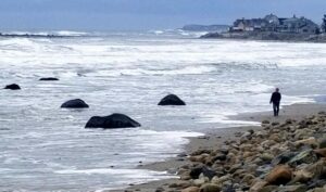
“So this is kind of a picture of what a future low tide would look like with sea level rise,” says Peter Slovinsky, a marine geologist with the Maine Geological Survey.
A recent nor’easter on Wells Beach was more of a glancing blow than a knock out punch, but the day after the storm, the surf remains high, part of the beach is under water at low tide and Slovinsky says it illustrates how low-lying homes and roads nearby are vulnerable.
For the rest of the story, including the audio version, please visit MainePublic.org. This story is part of Maine Public’s series “Climate Driven: A deep dive into Maine’s response, one county at a time.“